


near summit of Santa Ana Volcano – El Salvador
Climbing Santa Ana Volcano – El Salvador
Volcan Santa Ana is El Salvador’s highest volcano, with an elevation of 2381 M / 7857 ft. at the highest point of its crater rim. The rugged volcano is located in Cerro Verde National Park in western El Salvador, a one hour’s drive or a two-hour bus trip southwest of the small historic city of Santa Ana.
Volcan Santa Ana is an active volcano, with its last major eruption in late 2005. Nowadays, it features a vibrant-green steaming lake inside its main crater and stunning panoramic views to surrounding mountains, volcanoes and lakes.
When I read about guided hikes to the summit of Santa Ana, I knew I had to join a tour!
So after I got myself situated in Santa Ana and gathered all the details about making the hike, I set out early one morning to climb Santa Ana Volcano.
public buses in El Salvador
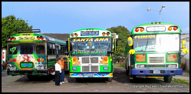
From Santa Ana town, hikers must take the 7:40 am bus #248 in order to arrive at Cerro Verde National Park before the guided hike leaves at 11 am. The next bus departure will not arrive in time. The bus takes about two hours to reach Cerro Verde National Park headquarters.
The day before I had prepared everything I needed for a rugged mountain climb. I took 2 liters of water, powdered electrolytes, 2 full meals (I know my body and I need to eat well. Lol), sunscreen, raincoat, rain pants, long sleeves, tights and an umbrella.
Even though it was warm enough for short sleeves and skirt midday in Santa Ana town, I knew that mountains can often become cold and weather can change suddenly. And it was raining at some point nearly every day during the two weeks I’d been in El Salvador, so rain was quite likely (It’s always wise to be prepared for all types of weather when climbing any mountains).
As it turned out, I actually used everything I took except the rain pants. Ate all the food, drank all the water and electrolytes.
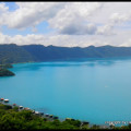
beautiful Lake Coatepeque – El Salvador
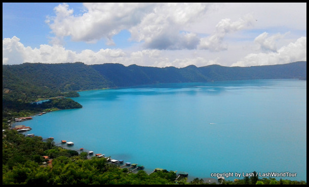
The bus trip was very scenic. It traveled around stunning Lake Coatepeque, a large crater lake with vibrant turquoise water, with several panoramic views from the crater rim as the bus whizzed by on the very winding forested road.
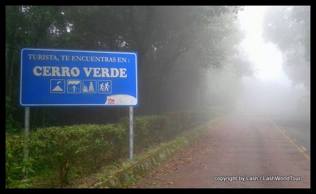
After passing halfway around the lake, the bus wound its way along more pretty forested roads and then zig-zag-ed up a mountainside to enter Cerro Verde National Park headquarters.
 We reached the entrance at about 9:30, so we had 1 ½ hours to hang around until the hike started. Besides myself, there were five other western visitors – one Japanese guy, two German guys and a Chilean-Swiss couple.
I befriended the Japanese guy, not so surprisingly. He was stunned to learn I speak Japanese, lol, so we hit it off and had several interesting chats about our world travel experiences. And we hiked together for part of the long climb.
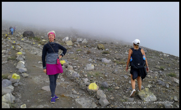
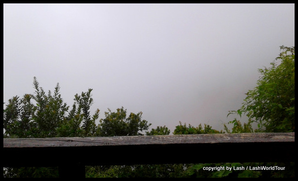
I knew from online photos that amazing panoramic views of nearby Izalco Volcano could be had at the park headquarters. Quite unfortunately, that morning, the entire area was fully socked in with fog. Views looked the this:
 Luckily, the park area had a few other nice attractions. For one, there’s a very unusual tree ‘tunnel’ that climbs along stairs up the hillside. There are plenty of colorful flowers in the gardens, several picnic areas and one restaurant.
After exploring, at about 10:30 I sat down to eat one of my meals before the hike began.
Much to my surprise, about 15 minutes before 11 am, suddenly several car loads of Salvadoreans arrived to join the hike. In total, there were 30 of us hiking that day, definitely the biggest group of people I have ever hiked with in my life!
I normally hike solo or with maximum 1-2 friends. But with guided hikes you never know how many people will be joining.
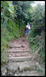
Happily, the entire hike was on mountain trails – dirt paths, rocky trails and high open volcanic slope. In the bottom elevations we walked along densely shaded, cool forests.
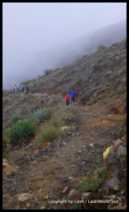
Higher up we hiked along open rocky trails on the mountain edges amidst scruffy vegetation and what would have been stunning panoramic views had it been sunny. Alas, we only saw thick white fog everywhere!
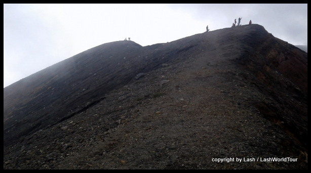
The last upper summit of the volcano (about one hour of the hike) consisted of steep, rugged rocky exposed slopes. The climb became harder and harder for most of us, as we gradually became more and more separated, struggling up the rough, steep slope.
At that point I was infinitely happy to have cool foggy weather for the day instead of hot burning sun. It was hard enough climbing without scorching sun and heat!
To my surprise, I found the hike quite challenging! I’ve climbed plenty of mountains and volcanoes in my life, so I’m quite accustomed to stiff hikes. Even so, Volcan Santa Ana tested my stamina and strength.
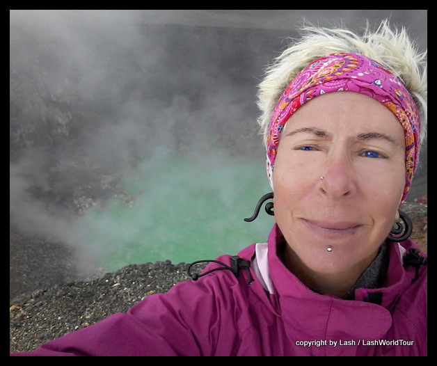
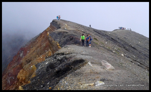
at crater of Santa Ana Volcano
Eventually, we all reached the crater rim. And suddenly the long, exhausting slog was well rewarded. There, 300 M / 1000 ft below, was a beautiful green caldera. Surrounding it, the inner crater walls presented fascinating rock formations with unusual textures, colors and formations. It was stark and stunning.
The undulating crater rim is 3.5 km in circumference. Part of that we could walk in order to see differing views of the inner crater as well as outwards to…what would have been stunning scenery. That day, there was just more white fog. Sigh.
Meanwhile, our trusty guide explained details of the volcano…
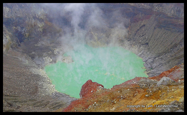
stunning crater lake inside Santa Ana Volcano
The brilliant green color of the lake water is composed of 90% sulfur and 10% of other trace minerals. Water temperature ranges between 45-60 C / 113-140 F and if you look closely, you can often see it boiling.
We were allowed to stay on the crater rim for 30 minutes before the descent. I enjoyed views into the crater and rested. Much too soon it was time to head back down the steep rocky slope.
Once again, we all became scattered along the mountainside as each hiker had a different pace and stamina. But eventually we all reached the base of the mountain, where we promptly sat down to rest and wait for the bus, which arrived one hour later.
crater rim of Santa Ana Volcano – El Salvador
Details for Climbing Volcan Santa Ana
Rugged guided hikes to the crater rim are lead nearly every day of the year from Cerra Verde National Park headquarters. From there, it’s a solid 2-hour climb to the summit, where hikers find a desolate landscape of barren gray slopes, randomly strewn rocks and scrubby vegetation.
On sunny days, the summit and much of the hike provide amazing views of neighboring Volcan Izalco, stunning Lake Coatapeque, and southward across El Salvador all the way to the Pacific coast.
However, during rainy season months from July to November the entire area is often shrouded in fog. On such days, hikers can usually at least see into the crater, but will entirely miss the surrounding panoramic views.
 On the ‘bright’ side, climbing the long, steep route to the crater rim is much cooler under cover of clouds or fog. With sunny weather, views are superb but visitors much take careful precautions against sunburn, heat issues and dehydration.
Visitors are only allowed access to the volcano on guided hikes which commence at 11 am every day. A policeman accompanies all hikes for extra security. No one is permitted to hike solo.
Near the park entrance a few accommodation options are available (check online or with park staff for details) but most visitors do the hike as a day trip from Santa Ana.
The trip to/from Santa Ana takes an entire day including the 2-hour bus trips each way, the 4-5 hour hike, and waiting time between the bus schedule and hiking times.
On sunny days visitors get their first amazing panoramic views of Volcan Izalco at park headquarters. But more likely than not, during rainy months, the ‘view’ consists of dense fog.
Be sure you’ve had enough to eat and drink before the hike since it’s a stiff 2-hour hike up the volcano slopes and another 1 ½ – 2 hours back down. Food is only available at park headquarters.
 Hiking Tips
Take plenty of water – at least 2 liters for the day. Even more is better.
Use electrolytes in at least one liter of your water, especially if it’s sunny (No, Gatorade is NOT an electrolyte drink, despite its claims. Get real electrolytes from a pharmacy in powdered form or bottles)
Make sure you have enough food and/or snacks. The entire day return, to/from Santa Ana is 11-12 hours – from 7 am to 5 or 6 pm.
If its sunny, be sure to use sunscreen or cover up all exposed skin. Most of the hike is completely exposed, with no sun protection or shade. Mountains are notorious places to get sunburned since the air feels cool so hikers often don’t realize they are burning.
If there’s any chance of rain, be sure to take a rain coat and possibly an umbrella and rain pants too.
Take long sleeves. The mountain air is usually cool to chilly.
 Costs
Costs
The bus costs $0.90 US one way. So it’s $1.80 round trip.
Hikers must pay for two national park entry fees. Cerro Verde costs $3 US. Santa Ana Volcano Park costs $6 US. In addition, the guide fee is $1 US per person. In addition, you might want to tip the guides a few dollars.
In total, the minimum cost to/from Santa Ana is $11.80 US, more if you want to tip the guides.
You might also find the following articles useful:
The 7 Waterfalls Tour – El Salvador
========================================================


 Hi! I'm Lash, an American nomadic world traveler who's been traveling solo since 1998. I’m passionate about traveling the world nomadically and then sharing it all with you. I hope to inspire you to travel the world, to entertain you with tales from the road, and to help you reach your travel dreams. Welcome!


1 ping