


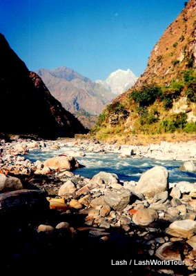
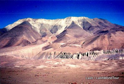
 Annapurna Range of Himalayan Mountains |
| Views of the Annapurna Range, part of the Himalayas in western Nepal |
HIKING THE ANNAPURNA CIRCUIT TREK, NEPAL
The Annapurna Circuit Trek in western Nepal is one of Nepal’s most popular hikes. As the name implies, it’s a circular hike- through the high valleys and mountain passes rimming the Himalayan Annapurna Ranges. Those soaring mountains rise to elevations of 5587 M-8091 M (17,000 ft- 25,000 ft) Most are over 7000 M (21,000 ft). Much of the trek itself is situated at 3000 M (9000 ft) That’s not quite high enough to bring on mountain sickness, but still quite high in elevation. The trek’s highest point is 5416 M (16,000 ft) at Thorung La Pass. The trek passes through a tremendous variety of topographies and many stone villages offering guesthouses, restaurants, and shops for the throngs of trekkers passing through. The trail marches along steep rising and falling trails, across vast flat arid valleys, and over several raging rivers.
 |
| stunning golden trees brighten an Annapurna valley |
Pokhara is the jumping off point for the Annapurna Circuit and several other hikes and mountain expeditions in the Annapurna region. Before starting their journey, every trekker must register at the government trekking office in Pokhara and pay fees to obtain a hiking permit. Annapurna Circuit fees totaled about $30 US when I hiked. Permits are granted to pretty much everyone who applies. High-peak mountaineering expedition fees are several thousand dollars, with permits somewhat hard to obtain.
 |
| Peak of distant Annapurna mountains |
Most hikers on the Annapurna Circuit trek counter-clockwise, starting on the eastern side of the Annapurna Range. They eventually climb up over 5416 M Thorung La Pass and return to Pokhara along the western side of the mountain range. For some reason, I decided to hike up the western side first and then decide later whether to cross over Thorung La Pass and down the eastern valleys or else backtrack down the western side. I think the issue was a possible lack of time to complete the entire loop due to my illnesses, which had lead me to criss-cross Nepal three times before I could actually start trekking. The western course is also called the Jomsom Trek, Jomsom being the major town way up in the high valleys, which actually has airport access.
Most people also hire both a guide and a porter to carry their packs. I elected to carry my own pack and go it solo, as usual. I’d always carried my own pack on my numerous backpacking and mountain climbing trips. That’s just standard, and ‘of course.’ I’m strong and capable. Why would I need someone else to carry my stuff for me? Besides, half the reason I enjoy trekking is the satisfying physical workout. I like carrying my pack!
As for a guide, I reasoned that since the Annapurna Circuit is in constant use by streams of hikers, the trail must be quite clear and obvious, with little or no chance of getting lost. So, what was the point of having a guide? Once again, I’d become accustomed to backpacking alone in wildernesses throughout the USA and Japan, with a trail book, map and compass. I figure that unless a trek is a very dangerous expedition or there’s a high probability of getting lost, I much prefer the personal challenge of doing it myself.
On top of all that, I have no desire whatsoever to go hiking with complete strangers. Out in nature I prefer solitude, peace and quiet, getting absorbed in my own thoughts and reflections, and basking in the wonderful sights, sounds, smells of nature. Unless I’m sharing the trip with a close friend or lover, I’m perfectly happy alone in the mountains. Even if the Annapurna guides and porters were free, which they’re not, I would not have invited them along. Annapurna Circuit solo for me, please.
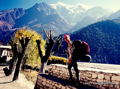 |
| Lash hiking the Annapurna Circuit, Nepal |
So one clear, sunny morning in Pokhara, Nepal, hiking permit in hand, I set out on my Himalayan trek. I quickly learned that from Pokhara to the trail head, without a guide to escort you by car, you have to take a local bus and get off at exactly the right spot. Generally, taking a local bus anywhere in Asia is not a big deal, but I didn’t speak any Nepalese. And, as it turned out, the trail head wasn’t marked anywhere along the road! Oops. Looked like my attitude, “Who needs a guide? It can’t be that hard to follow the trail” was already a little off the mark. I couldn’t even get started so clearly! Ha! I boarded the bus and crossed my fingers.
In the end, although a little confusing, reaching the trail head solo was certainly doable. All the Nepalis knew that any foreigners on the bus were heading for the trail head. The bus driver stopped at the right spot and the pasengers all pointed the way. From the roadside to the ‘official start’ of the trek I simply followed all the pointing fingers. That lead me to a small stone ‘plaza’ featuring a small temple, a few shops and watering holes: the actual start (or more often, the end) of the Annapurna Circuit!
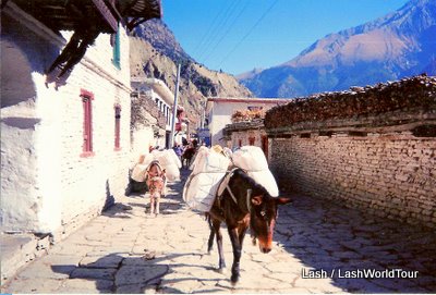 |
| Annapurna Trek’s wide, clear roads with pack mules |
Luckily for me, from that point the trail was absolutely clear. In fact, it was more like a road at most points. It alternated between stone and dirt, was well- trod, well-established, and much wider than I’d anticipated. Nepali porters filled the trail, carrying everything from restaurant supplies to construction materials to beds and furniture to trekkers’ backpacks. They were professional porters, meaning that was how they made their living: hauling huge loads of stuff up and down the steep mountains. Porters were essential because there are no roads in the Annapurna Region. Aside from the Jomsom airport, all villages, towns, schools, clinics, farms, and businesses can only be accessed on foot.
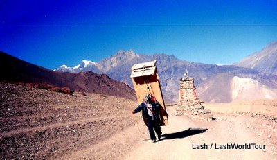 |
| Nepali porter carrying 2 beds up extremely steep slopes on Annapurna Circuit |
I was amazed at the huge loads those guys were carrying. First of all, Nepalese men are only about my size ( 5ft 5 / 55 kg) but solid muscle. Yet they were carry 40-50 kg loads. That’s 65% to 95% of their own body weight! The standard recommended sustainable load for backpackers is 25%-35%, maximum, of your body weight. I’ve foolishly carried up to 25 kg on mountain climbs before, still less than half my weight, and found it barely possible. I’ve found about 15 kg sustainable and 20 kg manageable for the first day or two until food supplies reduce the load. The Nepalis were carrying nearly their own body weight, day in day out, up and down steep stone stairs and mountain slopes. Those porter-ing hikers’ backpacks were usually carrying not one, but two, full packs! Unbelievable!
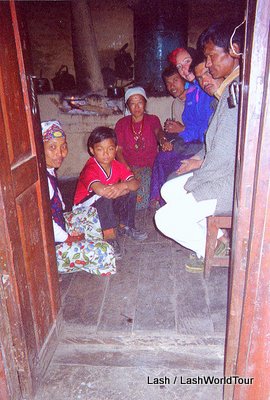 |
| Lash in local Nepali home in Annapurnas |
I was even more amazed when I realized they only eat once a day. That’s in the evenings, after their day’s work. They carry those heavy burdens all day long without any food in their bellies. I would keel over dead if I tried that. In the mornings they consume only one big mug of butter tea to sustain them for the entire day. At day’s end they finally eat a huge dinner, consisting of a heaping mound of rice, dahl, veggies and other bits, along with more butter tea or else strong local alcohol.
I discovered their eating habits by eating with the porters in local restaurants instead of at the tourist restaurants. Early on, I had quickly become fed up with those places. Everyone from the host to waitresses and hotel staff to other trekkers constantly asked me the same boring questions over and over and over, ad in finum. It was much more peaceful to eat with locals, who can’t speak any English, and thus were UNable to ask me questions. It was also infinitely more interesting to watch locals eat and interact with each other then join them in a swig of their strong local brew, served from a huge barrel in the kitchen.
In any event, as I hiked along day by day people were constantly amazed by me carrying my own pack. Eh? That’s just standard in my view! Of course most of the other hikers (using porters) were amazed. They were all wondering why on earth I would ever carry my own pack when I could have a porter. I was constantly wondering why on earth they were so whimpy that they couldn’t carry their own stuff while trekking. Different strokes for different folks. However, the locals were even more amazed than the westerners. They were so accustomed to watching foreigners not carrying their packs that they were astounded to see a woman… solo… carrying her backpack. Hmph. That’s just normal where I come from. In any event, throughout my entire journey people were constantly looking at me, either with admiration or wonder. I just did my thing.
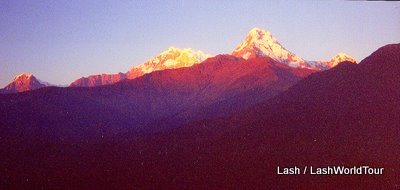 |
| view of Annapurna’s highest peaks at sunrise from Deorali Pass |
The route consisted of many really tough, steep climbs up and down mountain passes, usually on stone steps. I wonder how many thousands of steps I hiked in those mountains? Thankfully, there were also flat stretches along riverbanks, through valleys, and across broad open expanses of high plains. Almost every day I was either surrounded by distant peaks or could at least see 1-2 7000+ M peaks. Every day I saw interesting and amazing sights- of local life, of mountains/ rivers/ trees/ valleys, of the astounding porters marching with their burdens.
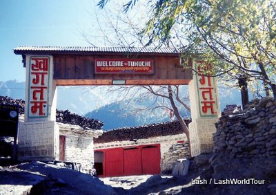 |
| Welcome sign at Tukuche village, Annapurna Circuit |
The trek passed through numerous villages of various sizes, most of them constructed entirely of stone. Most are filthy dirty and extremely noisy with screaming, racing children and loudly talking adults. The villages are all pretty basic in terms of sanitation and development, except for one real oddity. Many houses and lodges have solar panels on their roofs. What? Way up there, in the middle of the Himalayas, in villages only accessed by foot, with conditions barely beyond the dark ages…. Solar panels? Yep, there they were. That meant some porters carried all those panels up to the villages. And someone with the knowledge installed them. Eh? I could only guess it was the work of some NGO or other.
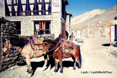 |
| riding horses tied up at Hillton Hotel, Annapurna Circuit |
The Annapurna Circuit is so popular and well-established that lodges, restaurants, shops and souvenir stores dot the entire route. There’s never a problem finding food or a warm place to stay. Those establishments all have English-speaking staff,, menus in English, western and Nepali food, rooms with big western beds and furniture, and hot showers even at basic lodges. It’s all pretty cushy for trekkers. In fact, most of the lodges I stayed at were very comfortable and quiet at night, due to the stone walls. (and probably the fact that all the hikers were exhausted) My only gripe was the never-ending-same-old boring questions day in and day out. I think I finally just stopped talking to people. I suppose they found me rude, but I just couldn’t handle the monotony by the time I was halfway through my trek.
 |
| Yak on Annapurna Circuit |
One amazing sight was yaks. I’d never seen yaks before. They were enormous, beefy creatures. Usually, they were adorned with colorful clothes and decorations. Equally amazing were the packs of brightly-clothed pack ponies up in the high valleys.
One highlight of the trek was the Deorali Pass at 3210 M. It was an exhausting climb that day to reach the top of the pass, where lodges were available. But from that peak were the Annapurna Trek’s most astounding views of Himalayan peaks. Stretched out before me were more than a dozen peaks, all over 7000 M, their tops pushing up out of clouds. The sunset and sunrise were superb!
 |
| Kali Gandaki Valley |
Another area I found amazing, and unexpected, was the wide, barren, windswept plains of Kali Gandaki Valley. It was utterly barren. Just brown-gray soil on absolutely flat land, stretching to the horizon, with distant mountain ranges on either side of the wide valley. And sooo dry! I’d been living in humid Japan and SEAsia for 10 years, so the dry air was quite unusual for me. So windy! The peoples’ faces certainly showed the affects of dry windy climate! Those faces were lined and wrinkled beyond belief! Someone 30 years old easily looked 50, someone 50 looked ancient. Although their faces were amazing to see, I vowed I would continue living in the humid tropics myself. Wow, what a difference climate makes!
 |
| village at the base of Thorung La Pass |
I hiked the western trails all the way up to Thorung La Pass, the northern most and highest point of the trek. Beyond that was the eastern side of the ranges. I stayed in the town at the base of the pass. In the morning I hiked up to the pass itself, without my pack, just to say I’d gone and to see the views. Then I returned to the town and hiked back to Pokhara via the western route again. I actually can’t remember why, having reached the pass, I didn’t just go up and over to the eastern side?
In any event, I enjoyed my return trek. Among other adventures, I had a psychedelic, super woman-on-cipro experience due to overdose of antibiotics, ended up hitting a child who attacked me and tried to steal my things, and ended the journey discovering that Maoist guerrillas had made a resurgence in Nepal, leading all western countries to order immediate evacuation of its citizens from Nepal!
The continuation of this story: Maoist Guerrillas and Dramatic Departure from Nepal
Q: Have you hiked in Nepal?
If so, what were your adventures and impressions?
If not, would you like to hike the Himalayas? Which trek?
——————————————————————————————————————————————
Did you know I wrote a guidebook to Hiking in Bali, Indonesia?
If you’re heading to Bali and want to hike, check it out:

Hiking in Bali – by Lash
Hiking in Bali 20 Hikes in Amed: Bali’s Remote Northeast Coast
My Hiking in Bali guidebook includes detailed information for staying in remote but charming Amed plus hiking preparations such as what to take hiking, getting to/from hike entry points, maps and photos. There’s also a thorough introduction to visiting Bali, with all the essential information tourists need upon arrival.
———————————————————————————————————————————————
You might also like:
Photo Gallery: Annapurna Circuit
Photo Gallery: Kathmandu, Nepal


 Hi! I'm Lash, an American nomadic world traveler who's been traveling solo since 1998. I’m passionate about traveling the world nomadically and then sharing it all with you. I hope to inspire you to travel the world, to entertain you with tales from the road, and to help you reach your travel dreams. Welcome!

4 pings
NEPAL: FIRST IMPRESSIONS - LashWorldTour » LashWorldTour
2012/02/29 at 2:46 am (UTC 8) Link to this comment
[…] were your impressions? What did you like and dislike about the country? You might also like:Trekking the Annapurna CircuitMaoist Guerrilla Bombings and Dramatic Departure from NepalDhaka, BangladeshPhoto Gallery: Hiking […]
MAOIST GUERRILLA BOMBINGS AND DRAMATIC DEPARTURE FROM KATHMANDU NEPAL - LashWorldTour
2012/06/11 at 10:48 pm (UTC 8) Link to this comment
[…] in any hairy situations while traveling?If so, please share your story here!You might also like:Trekking the Annapurna CircuitPhoto Gallery: KathmanduPhoto Gallery: Hiking the Annapurna Circuit (function() {var s = […]
7 Must-Have Items for Those Who Love Hiking - LashWorldTour
2020/07/31 at 8:11 pm (UTC 8) Link to this comment
[…] don’t take up much space, and can keep you dry and warm if bad weather does strike. Check out how to avoid hiking hell for more interesting tips and […]
Mount Semeru Trekking in Indonesia - How to Do it Solo | Hike Bike Travel
2025/02/13 at 3:28 am (UTC 8) Link to this comment
[…] And I’d been hiking/mountain climbing solo for 5 years, including a two-week trek of the Annapurna Circuit in the Nepal Himalayas. I’d even climbed another ashen-cone volcano – Japan’s magnificent Mt […]